UIP Size Comparison: Difference between revisions
Marioboyrc (talk | contribs) |
m (Reverted edit by RetroMCPussyFaggot99 (talk) to last revision by Samcraft3) Tag: Rollback |
||
| (10 intermediate revisions by 4 users not shown) | |||
| Line 1: | Line 1: | ||
{{UIP}} | |||
The '''United Imperial Provinces''' (U.I.P.) stands as one of the '''most expansive nations on [[RetroMC]]'''. Below is a detailed breakdown of its land value, size, population density, and how its member states compare to '''real-world landmarks and cities'''. | |||
== Land Value == | == Land Value == | ||
The total land value of the United Imperial Provinces is around $427,000. The table below breaks these calculations down by member state. <br> | The total land value of the [[United Imperial Provinces]] is around $427,000. The table below breaks these calculations down by member state. <br> | ||
[[File:Fixed Land Value.png|400px]] | [[File:Fixed Land Value.png|400px]] | ||
== Size == | == Size == | ||
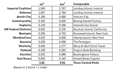
The United Imperial Provinces comprises an equivalent of 3.83 square miles (9.91 square kilometers). This makes it three times larger than Central Park in New York City. Below is a break down of these calculations by member state. Also included in the table is a landmark or other location that is roughly equivalent in area and/or floor area. <br> | The '''{{MCColor|&8|United Imperial Provinces}}''' comprises an equivalent of 3.83 square miles (9.91 square kilometers). This makes it three times larger than [https://en.m.wikipedia.org/wiki/Central_Park Central Park] in [https://en.m.wikipedia.org/wiki/New_York_City New York City]. Below is a break down of these calculations by member state. Also included in the table is a landmark or other location that is roughly equivalent in area and/or floor area. <br> | ||
[[File:AREA COMPS FOR ALL.png|400px]] | [[File:AREA COMPS FOR ALL.png|400px]] | ||
== Size Visualized == | == Size Visualized == | ||
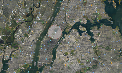
Here is what the size of the United Imperial Provinces would look like if placed over Central Park. <br> | Here is what the size of the '''{{MCColor|&8|United Imperial Provinces}}''' would look like if placed over '''{{MCColor|&8|Central Park}}'''. <br> | ||
[[File:UIP Over Central Park.png|400px]] <br> | [[File:UIP Over Central Park.png|400px]] <br> | ||
Here is a visualization when placed over London, including a few member states for comparison. <br> | Here is a visualization when placed over [https://en.m.wikipedia.org/wiki/London London], including a few member states for comparison. <br> | ||
[[File:UIP Layers.png|400px]] | [[File:UIP Layers.png|400px]] | ||
| Line 18: | Line 21: | ||
== Relative Landmass == | == Relative Landmass == | ||
Below is a table that assigns a historic empire to each member state as determined by a percent of the whole land area. For example, the Spanish Empire controlled roughly 11-15% of the Earth's land area | Below is a table that assigns a historic empire to each member state as determined by a percent of the whole land area. For example, the [https://en.m.wikipedia.org/wiki/Spanish_Empire Spanish Empire] controlled roughly 11-15% of the [https://en.m.wikipedia.org/wiki/Earth Earth]'s land area. [[SharkCity]] controls 11.87% of the '''{{MCColor|&8|U.I.P}}'''’s land area. Therefore, '''{{MCColor|&8|SharkCity}}''' got the '''{{MCColor|&8|Spanish Empire}}''' as a comparable. <br> | ||
[[File:Percent of total population.png|400px]] | [[File:Percent of total population.png|400px]] | ||
== Calculation Methods == | == Calculation Methods == | ||
Key methods used in calculations are listed below. | |||
*Each chunk was assigned a land area of 0.016 square kilometers before determining land area. | *Each chunk was assigned a land area of 0.016 square kilometers before determining land area. | ||
*Kekistan, Imperial Coalition, Goplexia, Amish City, and | *[[Kekistan]], [[Imperial Coalition]], '''{{MCColor|&8|Goplexia}}''', [[Amish City]], and [[Isometrycality]] were each reconciled to their pre-migration populations plus an adjustment for post-migration population gains. | ||
*All member states include any region that is considered to be political members of the respective member state. | *All member states include any region that is considered to be political members of the respective member state. | ||
*Land area for each member state includes any political entities that are not recognized by JVillage. | *Land area for each member state includes any political entities that are not recognized by [[JVillage]]. | ||
Latest revision as of 17:36, 6 April 2025
The United Imperial Provinces (U.I.P.) stands as one of the most expansive nations on RetroMC. Below is a detailed breakdown of its land value, size, population density, and how its member states compare to real-world landmarks and cities.
Land Value
The total land value of the United Imperial Provinces is around $427,000. The table below breaks these calculations down by member state.

Size
The United Imperial Provinces comprises an equivalent of 3.83 square miles (9.91 square kilometers). This makes it three times larger than Central Park in New York City. Below is a break down of these calculations by member state. Also included in the table is a landmark or other location that is roughly equivalent in area and/or floor area.

Size Visualized
Here is what the size of the United Imperial Provinces would look like if placed over Central Park.

Here is a visualization when placed over London, including a few member states for comparison.

Population Density
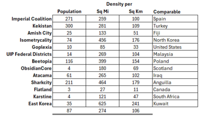
Based on the reconciled populations of the member states (see Calculation Methods), below is a table of estimated population densities of member states. Also included is a country with a comparable population density.

Relative Landmass
Below is a table that assigns a historic empire to each member state as determined by a percent of the whole land area. For example, the Spanish Empire controlled roughly 11-15% of the Earth's land area. SharkCity controls 11.87% of the U.I.P’s land area. Therefore, SharkCity got the Spanish Empire as a comparable.

Calculation Methods
Key methods used in calculations are listed below.
- Each chunk was assigned a land area of 0.016 square kilometers before determining land area.
- Kekistan, Imperial Coalition, Goplexia, Amish City, and Isometrycality were each reconciled to their pre-migration populations plus an adjustment for post-migration population gains.
- All member states include any region that is considered to be political members of the respective member state.
- Land area for each member state includes any political entities that are not recognized by JVillage.